- There are exceptional outdoor recreational opportunities in the Bitterroot Mountains year round.
- The Mountains consist primarily of public lands and as such they are open free of charge.
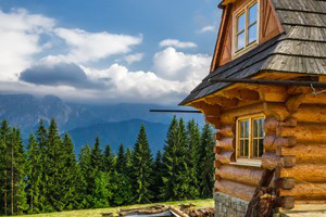
- Cabin and fire lookout rentals are available in several areas of the Bitterroot Mountains.
Overview
The Bitterroot Mountains are part of the Rocky Mountains and can be found along the westernmost edge of Montana and in the panhandle of Idaho. The entire mountain range encompasses nearly 5,000 square miles.
The mountains are bordered on the north by Lolo Creek, on the south by the Salmon River, on the east by the Bitterroot River and Valley, and on the west by the Selway and Lochsa Rivers.
There are three wilderness areas, Selway-Bitterroot, Anaconda-Pintler, and Frank Church-River of No Return, in the Bitterroot National Forest.
Hours/Seasons
The mountains are a place to enjoy year round. From scenic drives through the forests and hills, to off road adventures to include cabin and lookout rentals, camping, fishing, hiking, horseback riding, and in the winter, downhill skiing , snowmobiling, cross country skiing, and snowshoeing.
Fees/Costs
Most National Forests and Grasslands and Mountains, including the Bitterroots, are open, free of charge, for your use and enjoyment. Fees may be charged and permits required for some activities and locations. Business permittees, such as campground concessionaires and outfitter guides, may provide services to public land users for a fee.
Contact
Bitterroot National Forest
1801 North First Street
Hamilton, MT 59840
(406) 363-7100
Highlights
Summer Adventure
Adventure never ceases in the Bitterroot Mountains when options are at your fingertips like rafting, kayaking, hiking on over 700 miles of trail, horseback riding, hunting deer, elk, mountain lion, and grouse, fishing brook, rainbow, and brown trout, rock climbing, viewing and photographing wildlife and wildflowers. The Salmon and Selway Rivers are great locations for white water rafting or top-notch stream trout fishing.
Winter Adventure
In the winter opportunities are endless for snowshoeing, cross-country and downhill skiing, and snowmobiling.
Lewis and Clark Trail
Lewis and Clark blazed a trail through the Bitterroot Mountains and faced some of their severest challenges here.
Cabin and Fire Lookout Rentals
Choose from among several properties, from lonely fire lookouts perched atop a mountain to quiet primitive and rustic cabins nestled deep in the forest. Rental fees are used by the Forest Service to manage and maintain these historic cabins.
Lake Como Recreational Area
The area has three developed campgrounds, a large parking area, toilets, dressing rooms, a designated swimming area and a boat ramp.
Mountain Biking/Hiking
The US Forest Service maintains 3 mountain biking trails and there are numerous hiking trails.
Getting Here
From Big Sky, Montana head either north to I 90 and over toward Missoula. From Missoula follow Route 93 follows the valley 40 miles southwest through the Bitterroot Mountains to Lost Trail Pass near Idaho. The Bitterroot National Forest begins in the Bitterroot and Sapphire Ranges above the Bitterroot River.